This interactive map shows the comparison between the number of tobacco, vape, alcohol and junk food retailers and advertisements, and an area’s deprivation level, in popular shopping areas across the Wellington Region.
Thanks to the help of our volunteers, we will continue to map more areas around the Wellington region. To begin with, we chose to collect data in shopping areas with the lowest and highest deprivation scores to show a clear comparison. Please provide your feedback on our map here.
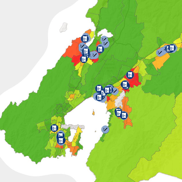
The Cancer Society originally created this map to support our health promotion advocacy campaigns to highlight the availability of cancer-risk products and vapes in local communities.
We also want to raise awareness in local communities about the difference in the number of retailers and advertisements between high and low-deprivation shopping areas. On the map, you can click on the icons to see pictures of these outlets and advertisements in different areas.
Deprivation scores are a way of measuring and comparing areas based on nine factors including housing, income, employment, transport, and education. For more information about deprivation scores, click here.
This is relevant because our map shows a higher number of these outlets and advertisements in high-deprivation shopping areas. These cancer-risk products, vapes and advertisements are more available in these areas which has added effects on the health and wellbeing of these communities.
Please note:
- Area Deprivation scores have been determined by Environmental Health Indicators NZ not, by the Cancer Society.
- We understand that area deprivation scores do not appropriately represent communities that live in these areas however, for the purposes of this map, deprivation scores are relevant to show the difference in the number and location of retailers and advertising between neighbourhoods.
- Data has been collected from main shopping areas in both high and low-deprivation suburbs to show the differences between areas with different deprivation scores.
Many of us know that maintaining a healthy weight and being smokefree are great ways to protect our health and reduce our cancer risk. But what many of us don’t know is how the places where we live, work and play influence the choices and behaviours we make as individuals. An example of this is the type of food we eat - If we live in an area with lots of junk food, this makes it easier to find and purchase junk food products and harder to avoid them.
This map can be used by community groups, councils, schools, organisations, and individuals to:
- Raise awareness of the availability of alcohol, junk food, advertising, tobacco, and vaping products in communities.
- Compare differences between the numbers and locations of alcohol, junk food, tobacco, and vape products sold in different areas around the Wellington region.
- Share this information with community leaders, councils, and other decision-makers to inform decisions about the availability of unhealthy outlets and advertisements.
- Create healthier environments by making informed decisions about the type of businesses that are open in your communities.
- Support advocacy campaigns such as the Junk Food Marketing Campaign and our Alcohol Campaign.
- Write a letter to an MP about changes you would like to see in different areas.